
Today I’m sharing some of the history on Offutt AFB. Unfortunately, everyone can’t just get onto Offutt. You need to have a military ID card to get onto the base freely, or make a friend with a military member who can sign you in as a guest.
As mentioned before, I started using this software to track my runs. The software doesn’t seem very stable on my iPhone (probably because I downloaded the free version and they want my money before it works the way I want it to…). So this isn’t the most accurate thing out there, but it’s fun to give it a go.
So here’s a map of the most recent run I performed:
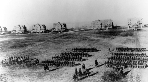
If you choose “view full” in the lower left, then select the satellite map (or Hybrid), you can see that I’m running the perimeter of a large field. This is the parade field of what was formerly Fort Crook, which was the original military installation that is now the home of Offutt AFB. Fort Crook was established in 1888, and was completed in 1894. Today, many of the buildings surrounding the parade field are from their original mid-1890s construction, including the buildings of “General’s Row” which are seen in the background here from the late 1890s:
And here are the same houses today, the same ones as on the left side of the above photo:


Recent Comments